
What Is an Elevation Certificate and Why Does Every Homeowner Need One?
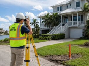 If you own a home, an elevation certificate could save you hundreds of dollars a year on flood insurance. It can even help remove your home from a high-risk flood zone completely. But most homeowners have never heard of it, and many are overpaying right now because of that.
What Is an Elevation Certificate?
An elevation certificate is an official FEMA document completed by a licensed land surveyor. It records how high your home sits compared to the expected flood level in your area. Insurance companies use it to set your flood insurance rate.
The document is called FEMA Form 086-0-33. A licensed surveyor visits your property, takes measurements, and fills out the form. The result tells your insurance company, your lender, and FEMA exactly where your home sits in relation to floodwater levels.
Without this document, your insurance company uses FEMA’s general estimates for your neighborhood. Those estimates are often wrong. Many homeowners end up paying more than they should simply because no one checked their actual elevation.
Why Homeowners Need One
West Palm Beach sits in one of the most flood-prone counties in the country. Palm Beach County has over 153,000 active flood insurance policies. Without an elevation certificate, many homeowners pay too much or miss out on flood zone removal entirely.
Here is why this document matters for you specifically:
- Your lender may require it. If your home is in a high-risk flood zone (zones starting with A or V) and you have a government-backed mortgage, you must carry flood insurance. Your insurer needs the elevation certificate to rate your policy correctly.
- You may be overpaying. FEMA’s new pricing system allows your insurer to use your actual elevation data instead of estimates. If your home sits higher than FEMA assumes, a certificate can lower your bill right away.
- West Palm Beach has a 25% discount built in. The city holds a Class 5 Community Rating System rating. That means NFIP policyholders in high-risk zones already get up to 25% off their premiums. An elevation certificate stacks on top of that discount.
- You may not need flood insurance at all. If your home sits at or above the Base Flood Elevation, a surveyor can use the certificate to apply for a Letter of Map Amendment (LOMA) with FEMA. A successful LOMA removes the flood insurance requirement completely.
What Is on an Elevation Certificate?
An elevation certificate has six sections. The two most important are Section B, which shows your flood zone and Base Flood Elevation, and Section C, which shows your home’s actual measured elevation. The gap between those two numbers controls your flood insurance premium.
Section A: Property Information
Your address, legal description, and flood zone label.
Section B: Flood Map Information
Your official flood zone (such as AE or VE), the Base Flood Elevation for your location, and the flood map panel number and date.
Section C: Building Elevation (Survey Required)
This is the section that drives your insurance rate. It includes:
- Lowest floor elevation
- Attached garage floor elevation
- Elevation of equipment like your AC unit
- Lowest Adjacent Grade (LAG): the natural ground level right next to your foundation
The gap between your Lowest Adjacent Grade and the Base Flood Elevation is called your freeboard. If your home is higher than the BFE, you have positive freeboard and pay less. If your home is lower, you pay more.
Section D: Surveyor Certification
Signed and sealed by a licensed Florida Professional Surveyor and Mapper. This is what makes the document official and legally valid.
How It Affects Your Flood Insurance Cost
Your elevation compared to the Base Flood Elevation is the biggest factor in your flood insurance cost. Each foot above the BFE can save you hundreds of dollars per year. Each foot below it raises your rate.
Here is a simple breakdown for homeowners:
Your Elevation vs. BFE | What It Means | Effect on Premium |
2+ feet above BFE | Very low risk | Lowest possible rate |
1 foot above BFE | Low risk | Significant savings |
At BFE | Baseline risk | Standard rate |
1 foot below BFE | Moderate risk | Higher rate |
2+ feet below BFE | High risk | Much higher rate |
In high-risk flood zones in Palm Beach County, annual premiums can run from $2,000 to over $10,000. A single foot of positive freeboard can mean hundreds of dollars in savings every year.
The numbers make the decision easy. FEMA says just one inch of floodwater can cause $25,000 in damage to a home. The average NFIP flood claim payout from 2020 to 2024 was more than $82,000. An elevation certificate that costs $400 to $700 and saves you $800 a year pays for itself in less than twelve months.
Who Can Prepare One?
Only these three types of licensed professionals can complete and certify an elevation certificate:
- Licensed Professional Surveyor and Mapper (PSM)
- Licensed Professional Engineer (PE)
- Licensed Architect
Florida law (Statute 472.0366) also requires surveyors to submit every completed elevation certificate to the Florida Division of Emergency Management. That means a certificate for your home may already exist in the state database, and you can check before spending any money.
How to Get an Elevation Certificate
Step 1: Check If One Already Exists
Search these free sources first:
- City of West Palm Beach portal: westpalmbeachfl.withforerunner.com
- Florida FDEM database: floridadisaster.org/elevation-certificates
- Your mortgage closing documents
Step 2: Hire a Licensed Local Surveyor
If no certificate exists, contact a licensed PSM. The surveyor will visit your property, take all required measurements, complete the FEMA form, and deliver your certificate in 3 to 7 business days.
Step 3: Share It With Your Insurance Agent
Give the completed certificate to your flood insurance agent and ask for a re-rating right away. Any savings apply from the re-rating date, not backward, so act quickly.
Step 4: Ask About a LOMA
If Section C shows your Lowest Adjacent Grade is at or above the BFE, ask your surveyor about a Letter of Map Amendment. A successful LOMA can remove the flood insurance requirement from your property completely.
How Much Does It Cost?
Property Type | Typical Cost | Turnaround |
Standard residential lot | $400 – $700 | 3–7 business days |
New construction | $300 – $500 | 3–7 business days |
Large or complex property | $700 – $1,200+ | 5–10 business days |
This is a one-time cost. The certificate does not expire on a set schedule, and there are no renewal fees.
Frequently Asked Questions
Is an elevation certificate the same as a land survey?
No. A land survey shows your property boundaries. An elevation certificate measures how high your home sits compared to the flood level. Both are done by licensed surveyors but for different purposes.
Does an elevation certificate expire?
It does not expire based on time. You may need a new one if FEMA updates the flood map for your area, if you make major improvements to your home, or if your lender requests a current document for a refinance.
Can I use a certificate from a previous owner?
Yes, in most cases. Check that the flood map has not been updated since the certificate was issued and that no major changes have been made to the structure.
What if my certificate has an error?
More than 50% of elevation certificates reviewed by flood specialists contain errors. A wrong benchmark or missing basement data can inflate your premium for years. A licensed surveyor can review your existing certificate and catch those mistakes.
For a free land surveying quote, call us at (561) 220-7505 or send us a message by going here.
Posted in land surveying, land surveyor |